 |
|
PM Nguyen Xuan Phuc at the teleconference on preparation for Molave storm
|
As the storm is set to hit and make landslide in central Viet Nam in the next few days, authorities planned to evacuate more than 1.27 million people from vulnerable areas to safer places.
Local leaders were asked to postpone unnecessary meetings to ensure safety for residents, stay in contact with and ask 59,477 fishing vessels with 289,298 workers onboard to find shelter while searching for remaining missing victims and minimize possible losses.
Director of the National Center for Hydro-meteorology Forecasting Mai Van Khiem was quoted as saying that Molave Storm is an especially powerful cyclone. It was projected to reach Level 12 to Level 13 and affect the Northern, Central, and Southern regions. Storm intensity was forecast to be equivalent to Typhoon Damray that affected Viet Nam in 2017 at the fourth natural disaster risk level.
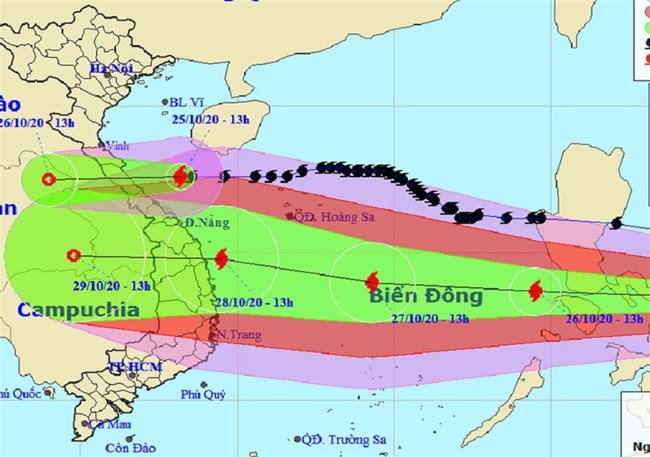
At around 8 a.m. on Monday the storm was around 650 km east-northeast of Southwest Cay islet, with winds of 135 kph.
For the next 48 hours it will remain on course and reach the sea area between Da Nang and Phu Yen at around 7 a.m. Wednesday. It will continue to pack winds of 150 kph.
In 72 hours, moving at around 20 kph, it will make landfall between Da Nang and Phu Yen, before weakening into a tropical depression.
The ninth tropical storm was forecast to bring heavy rains for central provinces especially Nghe An, Ha Tinh, and Quang Binh with average rainfall level of 500-700 mm from October 27-29./.
Powerful Storm Molave moving fast, forecast to hit central Vietnam Oct. 28
Storm Molave is moving westward at 20-25 kph into the East Sea, and is forecast to make landfall in the area from Danang to Phu Yen provinces on October 28, with strong winds at levels 12-13, gusting at level 15.
|
|
||
At 1.00 a.m. today, October 26, the eye of Molave was spotted in the central region of the Philippines, packing gale force winds of 100-135 kilometers per hour, gusting at level 14, the local media reported.
According to the national weather center, the storm will be some 350 kilometers northeast of Song Tu Tay Island at 1.00 a.m. tomorrow, with maximum winds blowing at 115-135 kilometers per hour, gusting at level 14.
In the next 24-48 hours, the powerful storm is forecast to move west-northwest at 20-25 kilometers per hour and may strengthen when heading toward Central Vietnam.
The storm may be centered some 240 kilometers east of the coastal area from Quang Nam to Phu Yen provinces at 1.00 a.m. on October 28.
In the next 72 hours, after hitting the central region, the storm will weaken into a tropical depression. At 1.00 a.m. on October 29, the eye of the storm may be located in the southern region of Laos, with gusty winds at level 8.
Due to the impact of the storm, many parts of the central region of Vietnam will experience torrential rains today, with rainfall measuring 20-50 millimeters. SGT/VGP/VNN
