The Hanoi Institute of Planning and Architecture, in collaboration with the city’s Management Board for Transport Construction Investment Projects, recently hosted a conference to unveil the detailed zoning plan for Ngoc Hoi Bridge.
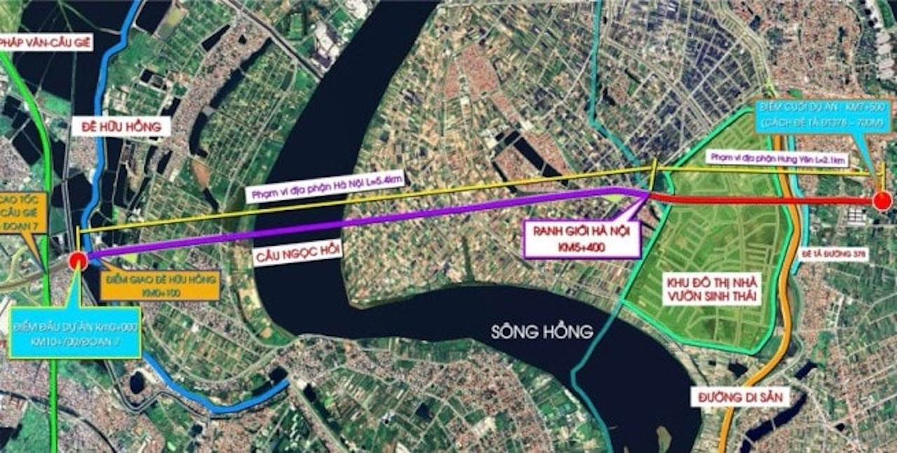
According to the plan, Ngoc Hoi Bridge is a special-grade infrastructure project. It will begin at the intersection with Ring Road 3.5 (from the Phuc La - Van Phu section to the Phap Van - Cau Gie Expressway) and end at Kim Duc Commune in Gia Lam District, bordering Hung Yen Province. The total route length is about 5.2 kilometers.
The bridge and its approach roads will feature a cross-section width of 33 meters, including six lanes for motor vehicles, mixed traffic lanes, and pedestrian walkways. A particular section - from Chu Cu Van Mausoleum to the Hanoi city boundary - will widen to 60.75 meters, with a central viaduct, service roads, and sidewalks on both sides.
Ngoc Hoi Bridge will lie along the planned Ring Road 3.5 corridor, with a total studied length of 7.5 km, including 5.4 km within Hanoi and 2.1 km within Hung Yen.
The project’s total investment is estimated at VND 11,844 billion, funded by the Hanoi city budget and the central government. The bridge will span the Red River, improving regional connectivity.

The starting point will be in Thanh Tri District (Hanoi), linking to the Ring Road 3.5 project segment from Phuc La – Van Phu to the Phap Van – Cau Gie Expressway, located about 360 meters from the Huu Hong dike.
The bridge will end in Van Giang District (Hung Yen), connecting to the local section of Ring Road 3.5, approximately 700 meters from the Ta Hong dike and near the Hanoi – Hai Phong Expressway.
According to the Hanoi People's Committee, Ngoc Hoi Bridge will enhance connectivity between Hanoi and Hung Yen, facilitating access to key new urban areas such as Ecopark, Dai An, and Dream City.
It is expected to drive economic and social development in the southern part of Hanoi and nearby provinces such as Hung Yen, Ha Nam, and Bac Ninh.
Currently, eight bridges span the Red River: Thang Long, Chuong Duong, Vinh Tuy, Thanh Tri, Nhat Tan, Vinh Thinh, Long Bien, and Viet Tri - Ba Vi.
Under the city's transportation development plan through 2030, with a vision to 2050, 10 more bridges are planned, including Tu Lien, Tran Hung Dao, Van Phuc, Hong Ha, Me So (Ring Road 4), the new Thang Long (Ring Road 3), Vinh Tuy (phase 2), Thuong Cat, Ngoc Hoi (Ring Road 3.5), and Phu Xuyen.
N. Huyen